Architectural Revit Models
Survey-Grade Floorplans, Elevations & Sections
Laser Scanning
Digitisation of Built Assets

From Scan To Plan
At PointBIM, we deliver 3D models, 2D building surveys, and laser scan data of existing buildings — fast, accurate, and ready to brief.
3D, BIM & CAD
We supply files in Revit, AutoCAD & IFC.
UK Wide Coverage
We work with architects, developers, and estate teams across the UK on projects from refurbishment to redevelopment and portfolio planning.
Clarity for Complex Sites
At PointBIM, we deliver 3D models, 2D building surveys, and laser scan data of existing buildings — fast, accurate, and ready to brief.
We work with architects, developers, and estate teams across the UK on projects from refurbishment to redevelopment and portfolio planning.
We supply files in Revit, AutoCAD, IFC, or whatever format your team needs to move forward into design and delivery and have a strong portfolio of completed projects in London, Cardiff & Bristol.


CASE STUDY PROJECTS
Case Study: Marylebone Portfolio Surveying
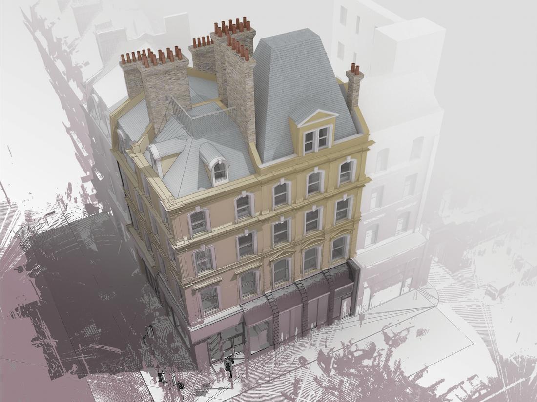
Over the past five years, PointBIM has delivered measured surveys and detailed Revit models for a wide range of properties across the Marylebone area.
Working closely with the same estate management team across multiple instructions, we have consistently provided high-quality Revit models, AutoCAD extractions, lease plans, and area reports to support ongoing asset planning and redevelopment programmes.
CASE STUDY: Kitchener Barracks, Chatham
PointBIM was instructed to deliver full measured survey documentation for the regeneration of Kitchener Barracks — a large former military site in Chatham with over 50,000 m² of buildings and grounds.
The site includes several Grade II listed buildings, adding heritage sensitivity to the project brief.
We provided a coordinated laser scan of the entire estate, Revit models including terrain and topography, and a traditional topographical survey in CAD. The outputs supported planning, design, and documentation across the phased redevelopment of this historically significant site.
Case Study: Bristol Robotics Laboratory
PointBIM was appointed to deliver a full Revit model of the Bristol Robotics Laboratory at the University of the West of England (UWE) — one of the largest academic robotics facilities in Europe, totalling over 23,000 m².
Working to tight deadlines in an active research environment, we provided a complete 3D laser scan and delivered a clean, fully aligned Revit model to support redevelopment planning and facilities management.
Can We Help with Your Next Project?
Whether you need a quote, a tender submission, or just advice on how to scope your Revit or CAD survey — we can help.
Send us your drawings, a short brief and a site location and we’ll get back to you with a fixed price.
Clear answers, honest pricing, no obligation.
For UK Quotes Call Ryan +44 7725 236671